Easement Surveys in the Sea to Sky
Professional Easement Surveys in the the Sea to Sky, defining clear path parameters across a parcel to legally grant utility networks or shared access privileges to adjacent properties.
Developing real estate, sharing infrastructure, or securing access across a neighbour’s parcel requires establishing clear, legally binding property rights. In the Sea to Sky, an easement is a specialized right that one person may exercise with respect to the land of another, requiring both a "dominant tenement" (the property benefiting from the right) and a "servient tenement" (the property burdened by it). Whether you are securing a critical access corridor, registering shared utility services, or resolving an encroachment, ensuring these rights are accurately mapped and legally defined is primary to the success of your real estate investment. As a dual-registered firm of British Columbia Land Surveyors (BCLS) and Professional Engineers, we deliver the professional geomatics engineering and high statutory authority required to accurately delineate your easement areas and protect your property rights.
Defining the spatial limits of an easement constitutes the "practice of land surveying" under the Land Surveyors Act, meaning only a commissioned member of the Association of British Columbia Land Surveyors (ABCLS) holds the exclusive statutory authority to determine, establish, and certify these boundaries. Relying on unlicensed individuals to map your access routes or utility corridors exposes your project to severe legal liabilities. An easement differs significantly from a Statutory Right of Way (SRW), as an SRW does not require a dominant tenement and is typically held by governments or public utilities under Section 218 of the Land Title Act.
Our professionals expertly navigate the complex legislative frameworks governing easements. Under Section 223 of the Land Title Act, if a dominant tenement is subdivided, the benefit of the registered easement is automatically annexed to each of the new parcels unless explicitly designated otherwise by the land surveyor on the subdivision plan. In multi-family developments, Section 69 of the Strata Property Act creates implied easements for vertical and sideways support, shelter, and the passage of utilities between strata lots and common property without the need for registration in the land title office; however, these implied easements for shelter and support do not apply to bare land strata plans. Furthermore, if an existing easement becomes obsolete or impedes the reasonable use of your land, our surveys support legal applications under Section 35 of the Property Law Act, which empowers the Supreme Court to modify or cancel registered easements.
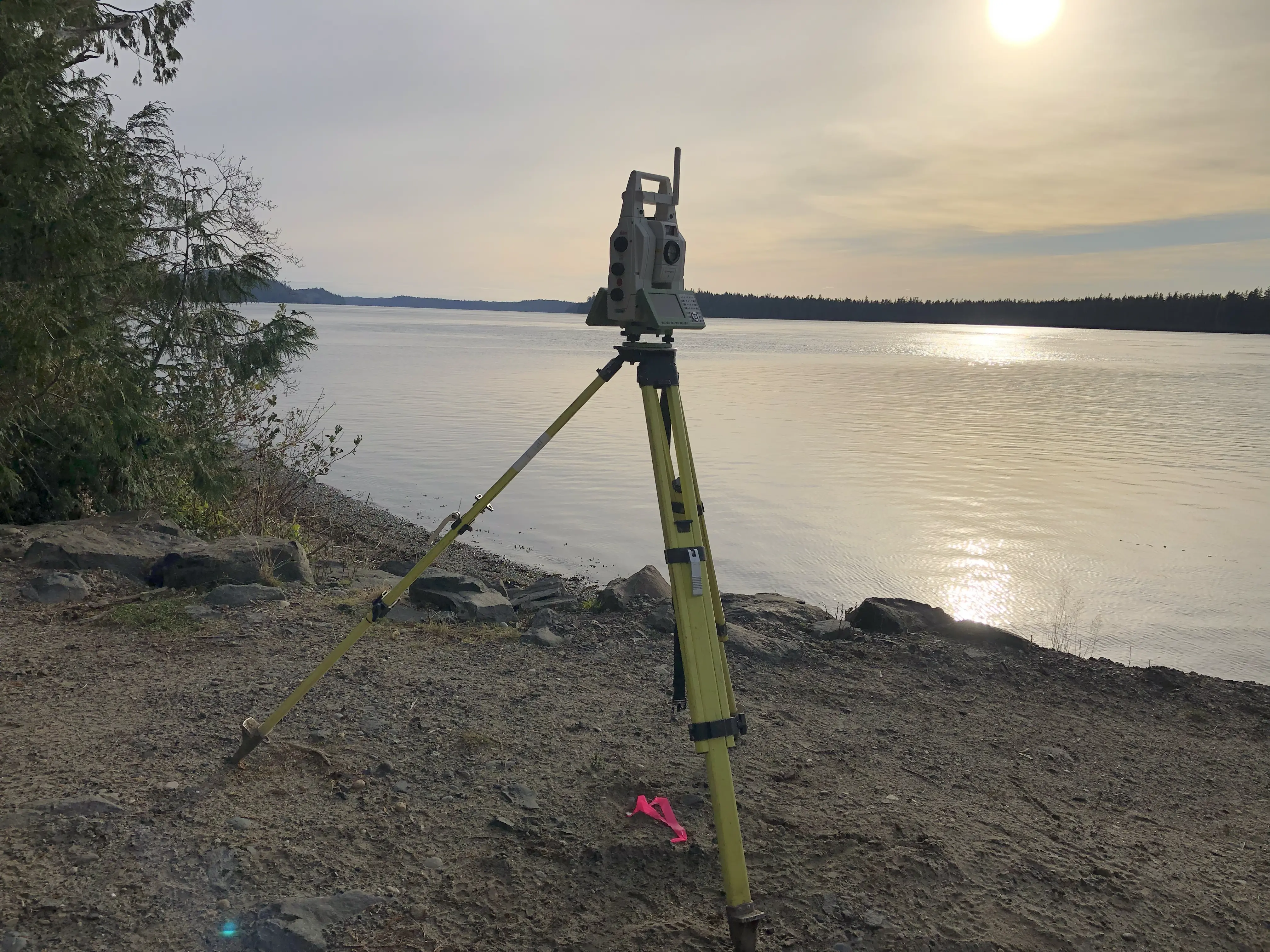
To achieve the high absolute and relative accuracy standards mandated by the Surveyor General and the ABCLS, our firm deploys an professional arsenal of cutting-edge geomatics equipment. During the preliminary mapping phase of expansive sites, we utilize Aerial Drone Photogrammetry and Aerial Drone LiDAR to penetrate dense vegetation and generate accurate 3D topographic terrain models. We establish a highly robust primary survey control network utilizing Static GNSS Receivers to integrate your property into the provincial active control system. From this framework, our survey crews utilize RTK GNSS Receivers for the rapid, centimeter-accurate positioning of legal boundaries in open-sky environments. In dense urban corridors in the Sea to Sky or under heavy tree canopy where satellite signals are obstructed, we deploy high-precision Robotic Total Stations to run closed-loop traverses. When an easement involves highly complex architectural features, party walls, or overlapping structural encroachments, we utilize Terrestrial LiDAR (3D laser scanning) to capture a accurate, high-density 3D point cloud of the as-built conditions, empowering our engineers to accurately draft the easement boundaries.
Why Choose Tantalus Geomatics?
Our team combines local the Sea to Sky expertise with state-of-the-art surveying technology. We deliver highly accurate, BCLS-certified plans that streamline your municipal permit approvals and protect your property investments.
Our Easement Surveys Process in the Sea to Sky
How do we ensure accuracy and efficiency in our land surveying projects?
Research
The foundation of a legally enforceable easement is documentary research. The BCLS accesses the Land Title and Survey Authority of British Columbia (LTSA) to retrieve the current Certificates of Title, historical plans, and surveyor field notes for both the dominant and servient tenements. We meticulously review all registered encumbrances, existing easements, and restrictive covenants to ensure the proposed easement layout avoids conflicts and accurately accommodates existing legal constraints.
Field Work
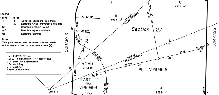
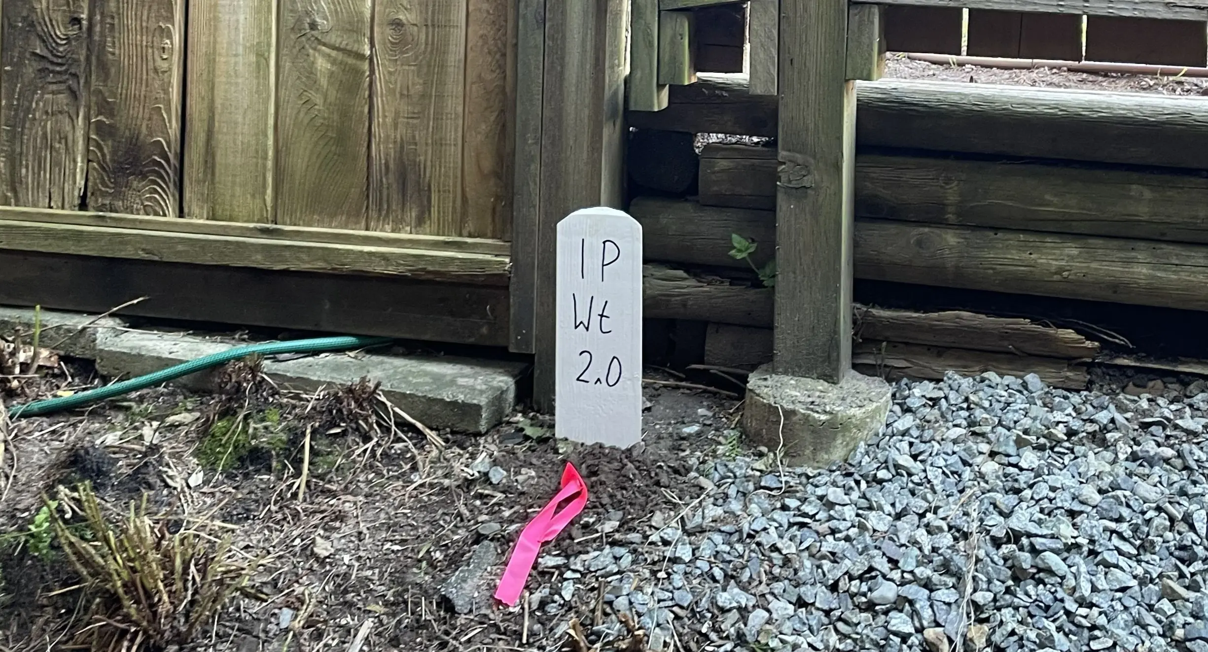
Before new easement boundaries can be established, the exterior limits of the parent parcels must be rigorously re-established on the ground. Our survey crews conduct a physical search to recover original survey monuments using RTK GNSS Receivers and Robotic Total Stations. The ruggedness of the terrain, the density of the vegetation, and the age of the original survey fabric directly impact the scope of the field work and the time required to complete the survey. Under the ABCLS Survey and Plan Rules, if a new parcel under survey intersects a surveyed easement that exceeds 6.5 metres in width, our crews must physically post the points of intersection with standard survey monuments. Once the physical evidence is captured, the BCLS legally adjudicates the true boundary lines and sets durable iron posts to mark the limits of your new easement.
Plan Preparation
Our drafting technicians translate the precise 3D field data into a highly regulated Reference Plan or Explanatory Plan under Section 99 of the Land Title Act. In strict accordance with the ABCLS Survey and Plan Rules, the boundaries of existing rights of way, easements, or covenant areas must be shown as broken lines. The plan meticulously illustrates the dimensions, bearings, and areas of the easement. As your certifying professional, the BCLS takes full statutory responsibility for the boundary resolution by electronically signing the Survey Plan Certification (SPC) using a secure digital certificate. The certified plan and associated legal agreements are then submitted to the LTSA to register the charge against the affected titles.
What professional documents and markers do you receive upon project completion?
What professional documents and markers do you receive upon project completion?
Certified Legal Plans
Digitally certified PDF Reference Plans or Explanatory Plans, fully compliant with LTSA standards, ready for deposit in the Land Title Register to secure your easement.
Property Corner Monumentation
Standard iron posts, lead plugs, or rock posts securely set in the ground to permanently mark the boundaries and intersections of the easement area.
Topographic 3D CAD Files
digital drafting files (DWG/DXF) mapping the easement boundaries and site topography for integration by your architects and civil engineers.
Point Clouds and Orthoimages
Dense 3D laser scan data and high-resolution aerial imagery providing a complete digital twin of the project site and any encroaching structures.
Frequently Asked Questions
Get answers to common questions about our land surveying services.
Local Resources for the Sea to Sky
Where can you find official topographic and permit checklists for the Sea to Sky?
Service Gallery
Field photos, survey plans, and technical captures from our projects.